


DHQ: Digital Humanities Quarterly
Editorial
Mapping Public Housing in Literature
Crystal Rudds <crystal_dot_rudds_at_utah_dot_edu>, , University of Utah  https://orcid.org/0000-0003-2430-7317
Introduction
While many participatory mapping studies analyze the space of American public housing
from geosocial, health, and economic perspectives ([O'Looney 1998];#wyley2010;[Boyde 2016];[Petteway 2019];[Hutton et al. 2022]; [Edmonds-Cady 2023]), none do so through the cartography of fictional literature. In geography and sociology,
maps are largely used to determine the borders of neighborhoods, economic differences
in income, access to labor opportunities, and other social factors, such as internal
catalysts for empowerment [Elwood 2002]. However, literary maps offer the opportunity to analyze how space is imagined,
what spatial aspects are culturally resonant, and how nuances in setting might reflect
hidden relations between ideas and place [Moretti 1998]. As one of the largest landing places for immigrants and migrants in the 20th century,
public housing communities have been a rich site for the literary imagination. Yet,
if one only relied on current literary scholarship to trace the contours of this site,
it would seem to illustrate a dearth in this imaginative geography. In this article,
we discuss the use of ArcGIS StoryMaps to connect narratives of public housing to
the geospatial locations of this geographically dispersed setting. We begin with a
brief discussion of the significance of public housing and the benefits of mapping
literature. We then describe the StoryMap and discoveries made during the exploratory
process of its construction, which culminated in interviewing affiliated residents
to solicit their feedback. We plan to expand the database and StoryMap used to organize
this project into participatory research tools that invite more residents to inform
the cultural representation of public housing by inspiring creative and scholarly
conversations about its evolving literature.
The first public housing communities in America were built in 1937 as a means of providing
transitional housing for veterans returning from war. However, what started as an
experiment in social welfare and mobility was quickly cast as a national problem due
to racial segregation, benign neglect, and lax screening protocols [Vale 2013];[Rothstein 2018];[Hirsch 2021]. In 1996, HUD legislation required the demolition of tens of thousands of buildings
across the country, scattering residents to both official “opportunity zones” and
less desirable segregated and similarly income-challenged neighborhoods. If we only
curated history from 20th century television media, we might accept the story of public
housing as an open and shut account of failed social policy. However, oral histories
and annual public housing reunions (many in commemoration of buildings that no longer
exist), testify that public housing communities are also and have always been neighborhoods
full of life and creativity [Hunter et al. 2016]. Internal determinants of successful neighborhood composition were overlooked for
decades in social science research [Leavitt and Saegert 1990];[Venkatesh 2000]. Creative works representing these communities have been equally under examined.
From roughly 1959 to 2023, novels, poetry, and juvenile fiction have been written
about public housing, yet this distinctive cadre of literature is rarely considered
in literary criticism and has been unevenly recognized by mainstream outlets. This
bibliographic oversight, we posit, is due to literary biases, inconsistent metadata,
and missing geographic information.
A major constraint to mapping public housing communities in literature is due to a
historical lack of vernacular specificity when distinguishing urban geographies carried
over from how we talk and write about them. Albeit culturally apropos in the 20th
century, the vernacular practice of subsuming low income and working-class residential
spaces under the catch-all moniker of “the ghetto” means that different architectural
spaces, such as tenements, kitchenettes, and shotgun houses in New Orleans, have not
always been clearly distinguished in critical discourse. For example, since the 1940s,
Richard Wright’s novel Native Son and Lorraine Hansberry’s play A Raisin in the Sun have stood as metonymic of the urban condition of African Americans; and yet, their
settings reflect the historical practice of redlining and racial covenants undergirding
private property relations in Southside Chicago. This would align their experience with the
well-documented phenomenology of slum living during this decade but does not capture
the alternative accounts of residents moving into newer public housing buildings on
Chicago’s south side, such as the Ida B. Wells and Stateway Gardens developments.
While we recognize that “geographies of places are imported but can be altered, warped, re-constituted, and
bent to the literary ambition of the work” ([Eve 2022, 106]), we also hold that studies of setting in literature have the potential to
reveal “place-specific dimensions of the locales that they depict” [Rambsy 2022, 4]. Specificity is important to analysis in both sociology and artistic representation
because “housing arrangements reflect different social relations vis-à-vis the state, law enforcement, neighborhood networks, histories of interracial and intra-racial
conflicts, mobility potential, and feelings of belonging” [Rudds 2022]. In addition to economic or political profiles of public housing, literary depictions
might convey what these communities personally mean to residents and expand our phenomenological
understanding of subsidized tenancy. This would also enrich scholarly conversation
about the 20th century and draw attention to its attendant literary biases. As a case
in point, we attribute another constraint on our research for the StoryMap to a non-existent
delineation of public housing literature amid top literary journals. Although our
database includes 100 titles associated with the setting of public housing in some
form, many of these works are self-published, and many would be classified as “black
crime fiction” or street literature. Street literature, an extension of both Black
radical imperatives and hip-hop culture, is often consigned to the shadows by literary
scholars, even while it excels in the marketplace [Gifford 2013]. Tangentially, independently published works, largely ignored by the critical establishment,
may offer more nuanced representations of place due to their not being tethered to
canonical significations, such as crime or disrepair.
Our first presentation on mapping public housing narratives took place at the Eighth
Digital Humanities Utah Symposium (DHU8) in February of 2024. There, the concept was
illustrated in Google Slides and consisted of a few images visualizing what one fictional
book had shown us about the potential of tracing public housing stories through literature,
metadata, and geography. Since then, as we describe later in this article, public
housing residents have influenced the actual design and text of the site so that it
now, albeit a work in progress, reflects our desire for inclusive engagement and,
if helpful, the segmentation of research interests.
[1]
At this stage, we have chosen to foreground the goals of the site rather than its functionality. For instance, the menu bar lists access
points that emphasize social interaction, e.g., “Community,” “Maps & Resources,” and
“Language & Justice.” The “Bookshelf” and “Academic Database” pages encourage both
scholarly and popular use in alignment with what we argue the body of public housing
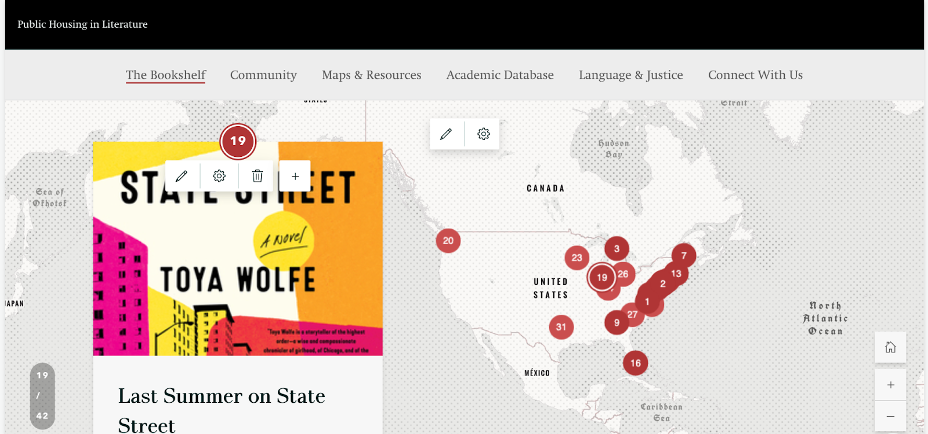
literature itself invites. If you were to scroll the Bookshelf, you would see rows
of vibrantly colored book covers, along with text summaries, linked to GIS points
across a map of the United States. The books range from best sellers like The Coldest Winter Ever by Sister Souljah to standing classics like Ayn Rand’s The Fountainhead to little known, self-published collections of poetry.
[2]
Together, the database and map of titles form a strong collection: covering eighty-two
years, authored by multiple ethnicities, and set across sixteen states — and counting.
While we include two graphs on the current version of the site indicating possibilities
of the dataset, we intentionally withhold from over-emphasizing the instrumentality
of this curated data. From the outset, we have worked to respect the historic marginalization
of public housing communities and their vulnerability to visual disparagement, that
is, to work against producing data displays for “data’s sake.” In this article, we
speak to the ethics of “black digital practice” — as Jessica Marie Johnson (2018)
defines it.
[3]
—as a guidepost. Even though public housing rests on indigenous land, in rural counties
(which in America we code as white), and as scattered sites of townhome developments,
it is its high-rise formations in city centers that have been compared to the Brookes
diagram.
[4]
Invoking slavery as a visual sign chain for public housing has served to denigrate
its viability as homespace, with this iconography often standing in as evidence of
the victimization or, alternately, the nihilism of residents, displacing socioeconomic
neglect onto allegations of a culture of poverty.
[5]
As Johnson argues, any effort at accounting for black life in a digitized space stands
the risk of rehearsing the ontological violence of data collection during the Middle
Passage and the slavery era when humanity was sublimated to use value. We extend this
argument to the economic and political violence of data, such as decontextualized
crime statistics used in modern abstractions of people from place (i.e., to rationalize
“slum” clearance, gentrification, and academic theft of knowledge and cultural capital).
Indeed, we note how a historical comparison of front pages of the HUD website illustrates
a changing data itinerary, with earlier years illustrating a prioritization of developers,
landlords, and government entities over tenants, and recent years — while displaying
a more evident hail to prospective (multicultural) residents — now emphasizing a proliferation
of data reports for researchers.
[6]
Socially just interactions with data call for researchers to “dismantle the residue
of commodification…in pursuit of more just and humane productions of knowledge” (Johnson,
2018, p. 65, 66). For us, this means recognizing that public housing residents have
maintained their own robust digital practice since the 1990s (Rudds, 2011) and, secondly,
endeavoring not to reproduce forms of quantification of neighborhoods for neoliberal,
capitalist ends.
[7]
As literary scholars practicing DH, we were and are naturally excited about tracing
publication histories, geographic markers, and textual similarities in theme and other
literary elements which, by themselves, promise to yield a rich portrayal of these
settings. We have chosen, however, to decenter these interests and focus on community
participation as a means of incorporating voices from the margin to generate grounded
theoretical observations.
Critical/Counter Cartography
The marginalization of public housing geographies automatically situates this as a
counter-cartographic project. At the heart of counter — or critical — cartography
is elevating understandings of space that are commonly overshadowed by the dominant
cultural perspective. In his quintessential article, “Deconstructing the Map,” [Harley 1992] relays the fallacy in positivism that correlates representation to geographic reality
while denying the complicity of mapmaking with imperial and colonial enterprises that,
in fact, distorted geographic documents of “discovery” to benefit those in power. Maps
are never objective. Though, on the one hand, they form a type of currency against
those in society deemed less powerful; on the other, as [Kelley 2021, 182] argues, “the map is a device that is severely limited by its formal and epistemological constraints.” Even as vehicles that have served the dominant interests at play (settler-colonialism,
city planning, global real estate regimes), every map is an assemblage of the visible
and invisible social economies at work in which space is parsed and negotiated differently
[Pickles 2004]. Alternative cartographic views have always existed, disrupting Western knowledge
production with clandestine routes, underground or maroon placemaking, border exchanges,
mutual aid, and “respatialization” through poetics [Kelley 2021];[Winston 2021];[Sparke 1998]; [McKittrick 2006]. Critical geographers and critical cartographers, then, amplify the constructed
and simultaneous nature of maps and mapmaking.
To think of the map as a text (and vice versa) destabilizes the authority of the
so-called “objective mapmaker" by juxtaposing the radical assumptions of critical
cartography with the range of “interpretative possibilities” [Harley 1992, 7–8]. Not only does literature inherently problematize the singularity of perspective
when it comes to describing place, the practice of literary mapping manifests as a
counter-mapping project in that the inclusion of place-based visual aids as part of
a given work always-already initiates the reader into the possibility that an entirely
independent world exists alongside the so-called real one [Piatti et al. 2009]. By nature of this juxtaposition of worlds, dominant and less dominant, fictional
and unreal, popular versus overlooked, the practice of critical or counter-cartography,
understood through the lens of literary mapping, means neither the text nor the place
can be thought of in isolation. Drawing on Toni Morrison’s uses of fiction to paint
liberatory maps for Black readers, ([Kelley 2021, 195]) points to the conceptual fluidity opened by Morrison’s depiction of place
as “both object and subject”: “Where we can map places as alive, changing, and feeling; as containing embodied and
independent meaning; as accruing memories and knowledge, we can begin to locate the
hidden and obscured possibilities within landscapes that appear closed, complete and
impenetrable.” We see the relevance to fiction about public housing in the reminder to regard both
the literature and public housing buildings as living artifacts that necessitate open
interpretation and, moreover, that inherently underscore the contingent (or, perhaps,
codependent) nature of cartography. Literature and, specifically, creative works about
public housing have the potential to illuminate overlooked epistemologies, pointing
us to the real and imaginative places where public housing residents establish their
own atlas of geographic meaning-making [Alderman2024].
Place becomes “space” when it becomes part of a larger narrative. [Wynter 1971] very helpfully demonstrated how West Indians of African descent defied the marketization
of their labor and bodies by cultivating their own little plots within the logic of
the plantation. [Parsard 2023] suggests that Wynter’s analogy between “the plot” and the West Indian novel is complicated
by the shifting infrastructure that supports property relations. In the case of America’s
public housing, we draw a similar analogy: residents converted large plots of governmental
land into “place” as soon as they began moving into their homes despite not having
ownership. They brought babies home from the hospital, hosted parties that ran late
into the night, organized social clubs, and created their own larger than life narratives.
These narratives of home were overshadowed for decades by public housing policy even
as residents mounted various forms of resistance to public housing’s segregation,
constrictions, and, later, demolition. Defining their place and recuperating this
space within the shifting logics of neoliberalism, mixed income development, and re-urbanization
has been accomplished largely through public housing residents telling a different
spatial story. The digitization of archival films, publicizing of oral histories,
and installations at institutions such as the National Public Housing Museum (NPHM)
support residents in documenting this counter-narrative in a multi-faceted way. By
working at the historical interstice between critical cartography and literary mapping
and working through a hopeful praxis of digital humanities, we see ourselves as contributing
to the current direction of “re”-presenting public housing spaces.
A novel that does the work of critical cartography as a part of its own project and
which serves as an exemplary case study from our data set is Toya Wolfe’s Last Summer on State Street, written in 2022. Wolfe is a former resident of the Robert Taylor Homes, which serves
as the novel’s central setting. The text depicts twelve-year-old FeFe (Felicia) Stevens
and her relationship with friends and family during a pivotal year in her adolescence.
Through the first-person narration, letters, and journal entries, readers follow FeFe
as she navigates the loss of her brother to gang participation and the mysterious
tragedy of a childhood friend. The novel deals with complicated familial relations,
fourth amendment violations, sexual abuse, and the self-actualization of its coming-of-age
narrator. Wolfe’s storytelling is compassionate towards her young characters and their
environment. Begun in 1999, the slow demolition of the Robert Taylor housing community
serves as the backdrop for the narrative, and we noted in our reading and discussion
how the book records building numbers and playgrounds that no longer exist. In Chapter
Three, for example, the buildings are personified as infants that have grown up along
with the residents, serving as shade and witness for neighborhood comings and goings,
as well as violence. Residents gather to watch the demolition of 4946, and the narrator
recounts, “That day is cemented in my memory. We watched them knock down what we thought
was indestructible. I’d learn that so many things that I thought were solid and structured
in my life could be broken down, bit by bit, just like those buildings” (p. 29). As
part of Chicago’s Plan for Transformation, Robert Taylor was developed into mixed income housing with a much smaller footprint.
Comparative satellite imagery in Figure 1 versus Figure 2 shows that much of the book’s
setting is currently open space and grass. Therefore, the novel serves as an important
archive for geo-cultural memory and a touchpoint for residents to compare their own
memories against.
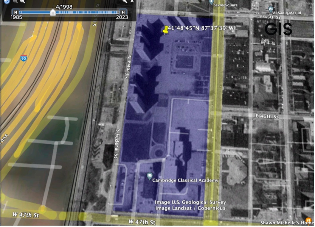
Figure 1.
Aerial view of Robert Taylor Homes in April of 1998.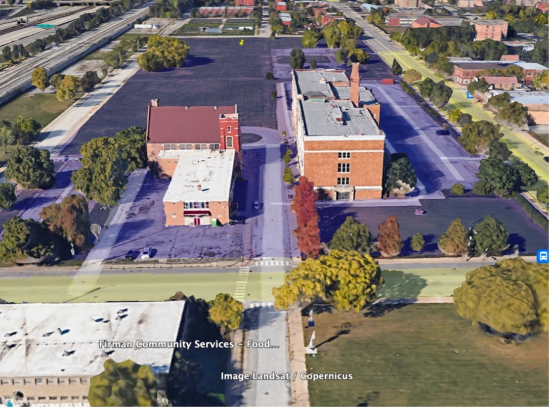
Figure 2.
Aerial view of Robert Taylor Homes in April of 2024.The poignant picture that Last Summer on State Street paints when juxtaposed with its real-world setting is distinctive because its geographic
realism allows for easy plotting. This discovery became apparent once we attempted
to use GIS software to map the other titles. While not all works emphasize geography
in the same manner, we argue that this collection of works illustrates examples of
geographic erasure in two ways, one more understandable than the other. First, like
ethnographic studies, authors might not include the specific name of the public housing
community for anonymity or creative reasons, and fictional names are difficult to
map in the realist sense we were attempting. Second, and far more common, we found
that some communities mentioned in the texts had been erased from the historic record.
That is, the physical coordinates, building blueprints, and other documentation of
these communities were challenging to find from a centralized source. While there
is a dataset from the U.S. Department of Housing and Urban Development of all current public housing locations that is available to the public and easily correlated through
GIS software like ArcGIS, a complete, central, reliable, and accurate record of the
country’s public housing communities from public housing’s inception is hard to find.
[8]
Albeit the ideal would be to pinpoint exact coordinates or building plans, in some
cases, we have aligned community names, both fictional and factual, to general geographic
areas.
Nevertheless, curating the database led to several findings likely of interest to
scholars from a wide range of disciplines, including geography, computer science,
GIS, information sciences and sociology. For example, a quick profile from the StoryMap
shows that more texts are set on the East Coast rather than the West (see Figure 3).
Does that geographic region have more accessibility to publishing outlets or encourage
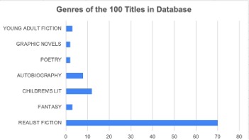
storytelling in some demonstrable way? Figure 4’s graph reports far more fiction in
our database than any other genre. Yet, non-fiction books, such as Ben Austen’s High Risers (2018), are more well-known. What types of narratives capture mainstream attention, and
what is the relationship of their authors to the literary/publishing industry? There
are also technology questions that our curation raises. For example, in conjunction
with manual searches conducted within library databases, we also
 queried ChatGPT for potential titles that would fit our criteria. ChatGPT did not
provide any titles that we didn’t already have, despite tweaking and revising our
prompt. We searched extensively for each title that the software provided, and many
had no digital presence or findable ISBN. Eventually, as we now know about AI, the
generative assistant began hallucinating titles rather than suggesting actual works
of published literature. This discovery implies that finding public housing literature
is a digitally undocumented task and confirms a need for human intervention in the
curation of this archive.
queried ChatGPT for potential titles that would fit our criteria. ChatGPT did not
provide any titles that we didn’t already have, despite tweaking and revising our
prompt. We searched extensively for each title that the software provided, and many
had no digital presence or findable ISBN. Eventually, as we now know about AI, the
generative assistant began hallucinating titles rather than suggesting actual works
of published literature. This discovery implies that finding public housing literature
is a digitally undocumented task and confirms a need for human intervention in the
curation of this archive.
Figure 3.
Book Cover and Correlating Map Point.
Figure 4.
Represented Genres.Methodological Considerations
In addition to aggregating titles, our inquiry led us on a journey through mixed methods.
Because the research began as exploratory, we didn’t formalize an overarching research
question, although if we had to do so retrospectively, it might be “how can a map
of creative works on public housing connect the way we understand metadata to the
ways that public housing residents tell and want to see their stories told?” This
question underscores meta dissonances in the correlation between geography and the
literary imagination, as well as emphasizes the significance of acknowledging and
including residents in descriptions of public housing spatiality. Here, we share about
discoveries of inconsistencies in MARC records and our attempt to create a controlled
vocabulary. We discuss our identities as non-public housing residents and the pivot
to include qualitative research (semi-structured interviews) while keeping black digital
justice ethics in view.
We originally thought mapping or aligning the titles with real locations was the only
intervention of the project. To amass our 100 titles, we used book summaries, reviews,
and prior encounters with the texts to develop the beginning of the collection. It
took multiple attempts and cross-referencing to establish a stable reference set.
Our initial approach to finding this literature was compiling a comprehensive list
of search terms to query online catalogs, mainly WorldCat, the Library of Congress,
and the University of Utah’s library databases. Many of the search terms we applied
did not yield results, or did not yield the same results across catalogs, despite
the boolean operators and truncation that were employed. Less than 37% of the books
in our current database are recognized by the Library of Congress catalog. It, therefore,
became clear that we needed to bolster our natural language searching by incorporating
subject heading searches, as well ([Frandsen, Carlsen, and Erikson 2024]), which prompted us to start thinking about MARC records and the different ways
these texts are digitally stored.
The purpose of the MARC (Machine Readable Cataloging) record is to maximize what it
pulls from library databases [Byrne1998]. Since one of the major ways the MARC record accomplishes its goal of discoverability
is through Library of Congress subject headings, LOC headings are inherently generalized
and standardized. That said, assigning vague terms to complex and nuanced texts can
be problematic as this classification tends to flatten intentionally contoured literature. We
began by compiling a list of subject headings that might be relevant, including terms
like “public housing” and “subsidized housing,” but we discovered that the way library
catalogues apply these terms to MARC records differs based upon the individual cataloguer
or institutional practice, resulting in inconsistent and sometimes biased descriptors
[Olson 2000].
It became apparent that the inconsistent subject headings associated with these texts
was also worthy of exploration and more critical attention. Significantly, only about
thirty of the fictional works included “public housing” as a subject heading. In Figure
5, you will see a MARC record for the national bestseller Deacon King Kong that includes the subject headings “public housing” and “neighborhoods.” In contrast,
Figure 6 shows a MARC record for Desperate Hoodwives: An Urban Tale which, while less popular, was still published by a major press. The subject terms
used in this record include “African American women” and “inner cities.” Despite both
novels incorporating a public housing community, only one indicates this in its metadata.
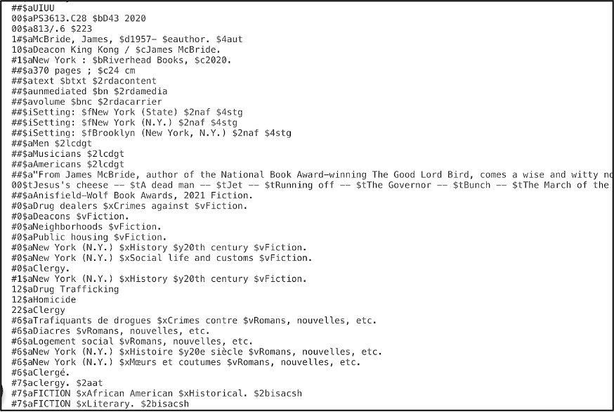
Figure 5.
MARC Record for James McBride’s Deacon King Kong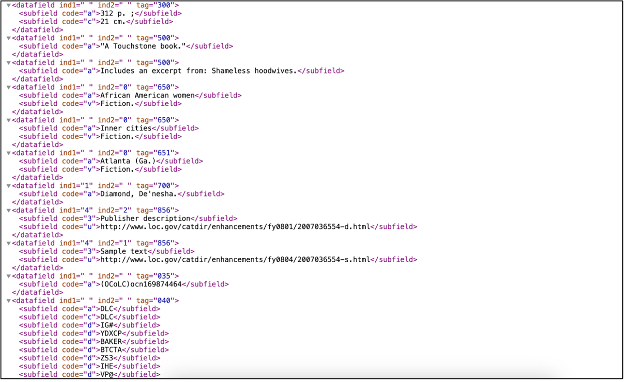
Figure 6.
MARC Record of Desperate Hoodwives: An Urban TaleAnd, while the latter’s subject headings seem obvious from its title, as McCoy expresses,
the category of “urban” is sometimes automatically interpreted as coded language for
racial and socioeconomic signifiers, when these may not always be appropriate.
Moreover, we found that books written about Chicago might include the tag “inner cities”
while books set in New York might only include the tag, “city and town life.” Some
entries are tagged with the subject “low-income housing” while others are classified
with the term “apartment dwellers.” Some books are associated with the tag “Single
parent families” in contrast to the more generic “Family Life.” Some tags were comprised
of twenty-seven headings, some tags only had six, some didn’t have a MARC record at
all. Some tags included a geographic identifier. Others didn’t.
Recognizing that the contribution of subject headings by libraries (and, often, a
single overworked librarian) is a “new” or contemporary practice ([OCLC 1991]), these divergent classifications, even if benignly added, reflect subjective and
sociological perceptions of spaces that carry culturally laden meanings. They also
reify ossified binaries, such as between the idea of literary and “genre fiction,”
and mainstream (or, “White”) cultural identity versus those identities deemed ethnically
other. Not only does this divergence affect whether these books are found in certain
searches, but it potentially impacts who chooses to read them. #wintermute2024 recommend preserving the original LCSH tags as an access point while juxtaposing
alternative subject headings through visual display and/or local library data flows.
[9]
After learning about the constraints that come with doing literature specific queries
in library databases, we were curious to see if searching crowdsourced databases yielded
more results. We found that this was in fact the case and were able to gather many
more titles with the help of community-based databases like Goodreads than we were
within the limits of controlled vocabularies. This discovery informed our hypothesis
that engaging residents who have relationships to these communities to provide input
on what’s wrong with or should be added to these classifications would make the subject
headings more meaningful, overall.
Thus, an intentional step in creating the database was to begin to categorize these
books in a standardized, yet nuanced way that would mean something to the people we
anticipate one day interacting with the data. After guidance from our librarians
at the University of Utah,
[10]
we concluded that the Dublin Core Metadata Element Set would work best for this stage
of the research for its flexibility and capacity to crosswalk with Marc 21. Although
the Dublin Core schema is robust, we did not use all its elements. In fact, we altered
six of its element titles, including the “Coverage” metatag which we replaced with
a unique data element of our own — GIS location. We did this primarily with audience
relatability in mind, for example, “Genre” and “Name of Community” are less ambiguous
to non-LIS users than “Format” and “Relation.” We also wanted to forecast the distinctions
we believe are important for demarking public housing literature and acknowledging
its geographic history. Since the renaming of the development is a frequent side effect
of public housing being demolished, privatized, or redeveloped into a mixed income
demographic, preserving the original names (and nicknames) of these neighborhoods
is an act of cultural preservation.
| Dublin Core Schema | Our Schema (*additions are highlighted) |
| Title | Title: A name given to the resource. |
| Contributor | N/A |
| Coverage |
GIS Location (Longitude and Latitude): The spatial or temporal topic of the resource,
spatial applicability of the resource, or jurisdiction under which the resource is
relevant; in, our case, the GIS coordinates of the community, city or state that is
named in that order of priority
|
| Creator | Author: An entity primarily responsible for making the resource. |
| Date | Date: A point or period of time associated with an event in the lifecycle of the resource. |
| Description | Description: an account of the resource (book summary, etc.). |
| Format | Genre: One of the following categories: fiction, narrative nonfiction, poetry, children’s literature, memoir/autobiography. |
| Identifier | ISBN: An unambiguous reference to the resource within a given context. In our case, the identifier became the ISBN. |
| Language | N/A at this time *due to emphasis on the US although we recognize that there are novels from around the world set in public housing (the French banlieues, for example) and this may become an important category to future researchers. |
| Publisher | Publisher: An entity responsible for making the resource available. |
| Relation | Name of community: The public housing community/s being discussed in the given text; may be real, fictionalized, or a local nickname |
| Rights | Copyright: Information about rights held in and over the resource. |
| Source | N/A |
| Subject | Worldcat Tags: How the Worldcat database categorizes each title. |
| Type | N/A |
Table 1.
Our Working Dublin SchemaThis indeed expands our project from mapping to metadata analysis, and — with enough
interest from libraries or information specialists — perhaps to a more formalized
updating of controlled vocabularies through community or grant partnerships. For this
aspect of the intervention, a community or crowd-derived controlled vocabulary would
be the ultimate goal.
A Black Digital/Spatial Humanities Lens
The geo-visualization that we aim for may allow for fascinating computational patterns
to emerge across texts and settings over time. But we take caution from Black Digital
Humanities and Black Spatial Humanities scholars to be wary of DH tools that exploit
already vulnerable sites of black collectivity with histories of oppression in relationship
to technology [Gallon 2016];[Scott 2022]. Therefore, we pause in this article as we did in our research process to resituate
this project vis-à-vis its most important stakeholder: the subject of this literature’s
representation, residents. Economically, the average income of public housing residents in the US was $16,000
in 2021 according to USAFacts.
[11]
Racially, the composition of tenants living in 2021 was 42 percent Black/African American,
33 percent White, 19 percent Hispanic of any race, 4 percent Asian or Pacific Islander,
and 1 percent Native American.
[12]
The bulk of all public housing households (~53%) are headed by someone 62 years of
age or older
[13]
; about 25% of people living in public housing are also classified as disabled. These
statistics reflecting economics, age, race, and ability can and have been used to
stigmatize groups in society, as well as to technologically facilitate over-bureaucratization,
exclusion from services (including digital/internet), and racial profiling.
The history of housing discrimination is intersectional and mappable. From the first
federally erected buildings in the 1930s, the government’s collusion with the Home
Owners’ Loan Corporation (HOLC) determined the probability that millions of people
would experience loan, employment, and insurance discrimination and, thereby, extreme
wealth inequality, higher mortality rates and adverse health risks, exposure to police
violence and incarceration, and even a greater number of housing code violations [Hillier 2003];[Shah et al. 2018];[Cammett 2016]. This national policy of redlining certain areas (that is, grading them with a “D”
for undesirable) was conducted through unobjective bank applications and maps and
converged with the 20th century’s less formally organized racism: blockbusting and
race mobs. Public housing, the penultimate chess piece in this mapped inequity, was
built in areas that would appease a racist housing market and contain the perceived
risks of integration. By the 1960s, the composition of public housing households had
transitioned disproportionately to Black or African American renters with buildings
over 90 percent Black in large urban cities like Chicago, a racial conversion, as
[Rothstein 2018] has shown, by design. Biased homeowner associations, sociologists, and media have
historically associated neighborhood nuisance with Black people, conjuring pejorative
stereotypes, such as ‘welfare mothers,’ ‘super predators,’ and ‘absent fathers,’ as
labels for Black women, children, and male partners. Thus, as they have served as
the “face” of public housing for decades, Black people were made uniquely vulnerable
to experiences of such stigmatization and the resulting segregation, surveillance,
demolition and displacement. However, as [Lipsitz 2011, 12] notes, “The first racial zoning ordinance in the nation was intended to clear
Chinese residents of San Franscisco out of desirable neighborhoods and confine them
to slum neighborhoods adjacent to polluting factories and noxious waste dumps. The
restrictive covenants used everywhere to deny housing opportunities to Blacks also
blocked Asian Americans, Latinos, and Native Americans from neighborhood choices.”
For both natives and immigrants, one’s ability to move around freely is always constrained
by shifting perceptions of economic competition or threat within the racial hierarchy.
Therefore, the relationship between non-White communities in public housing and mapping
cannot be discussed without attention to how maps have been weaponized against them
in service of the state’s privileging of its carceral and capitalist interests, and
whiteness.
Because of their particular focus, Black Digital and Black Spatial Humanities gives
us a lens to think through some of the implications of our work. For example, we take
heed to Tara McPherson’s insight that DH must be wary of its convergence with the
visual history of race and the racist history of digital computing: “The popularity of lenticular lenses, particularly in the form of postcards, coincides
historically not just with the rise of an articulated movement for civil rights but
also with the growth of electronic culture…born in quite real ways of World War II” [McPherson 2012, 144]. What McPherson terms “lenticular logic” is her way of pointing to the reliance
on spectrality in the 20th century (lynching postcards, news clips of racial mobs,
etc.) as in some ways an over-reliance on metonymy which can be decontextualized and
lead to fragmented analysis. We understand this to mean that a visual map highlighting
particular stories may reify overfamiliarity with associated stereotypes and genres,
and that we should carefully frame these stories as examples of unique viewpoints
and not attempt to speak on behalf of a singular resident experience. For instance,
although our database reflects writers who are majority Black, it also contains texts
by non-Black authors, and even by non-Black, non-former or non-current residents.
Our aim is not to reproduce a colonizing gaze that separates groups into presumed
subjectivities that bear the burden of cultural history. Rather, through the dynamic
interactivity of the StoryMap and the diversity of the collection of works, the goal
is to encourage users to draw their own conclusions about the relationship between
the texts, space, place, and themselves.
Furthermore, [Noble 2018, 32] counsels that digital humanities should be as interested in questioning “the
uneven distribution of information technology resources, how it sustains cultural
centers that are implicated in the suppression of Black life diasporically” as much
as it is in advancing cultural scholarship. The thrust of her argument is advocacy
for a “mash up” of African/Black diaspora studies and DH goals, that is, to consider
how the presentation and manipulation of data might also emphasize, or less ideally–contribute
to, practices of inequality. When it comes to the relationship between public housing
and higher ed, for example, we must acknowledge that university expansion has historically
pushed low-income residents out of their homeplaces while maintaining exorbitant tuition
that prevent those same residents from sharing in the life of the university. Thus,
our project takes seriously overarching questions like: What are the ethics of trying
to represent a space that has been erased from the landscape in many of our major
cities and when so many people’s relationship to shelter is precarious? What benefit
is there in mapping these novels beyond scholarly fascination? How does the project
leverage university resources while also necessarily illuminating historic institutional
complicity in dispossession? And what are methods to encourage intertextuality or
fresh engagement such that traumatic historical memory attached to the cartography
does not supersede present encounters with the possibilities of the data as text?
Resident Involvement
What these questions illuminated to us is that engaging with this archive requires
more than the knowledge of scholar-researchers who are non-public housing residents.
Working as an assistant professor of English and an undergraduate research assistant
now LIS graduate student, we have both done extensive reading on public housing and
its history, as well as begun reading the primary sources in our database. I (Crystal)
am African American, and Theadora identifies as White. However, while one of us (Crystal)
interned in the community of Cabrini Green in summer of 2009, has organized with displaced
residents for Section 8 rights, and participated in the Beauty Turner Academy of Oral
History sponsored by NPHM, ethnographically, we would characterize our relationship
to public housing as residential outsiders. Furthermore, vis-à-vis what some would
describe as demographic vulnerability due to economic indicators or proximity to the
justice system, we want to be transparent about our status as middle-class women in
advanced degree positions who are currently not experiencing housing insecurity. Therefore,
we acknowledged from the outset of this research that our positionalities might encode
blind spots that we desired to avoid to the extent possible. To mitigate our ignorance,
we engaged in one-on-one interviews with former public housing residents and more
closely affiliated scholars to solicit their input on the unfinished StoryMap and
database.
[14]
Our interviews were informal but reflective of qualitative research standards. We
informed participants that they were not the subjects of our research, however, still
requested their formal consent and asked the same set of semi-structured questions.
Nahisha McCoy is the tenant association vice president and a youth development leader
in the Red Hook Community of Brooklyn, New York. A. Adenike Phillips is a retired
food scientist, educator, and poet, who is writing a memoir about her family’s experience
as one of the first tenants of James M. Baxter Terrace Housing in Newark, New Jersey.
Although Phillips never lived there herself, she has a photograph of her father standing
in front of the painted entrance, the same entrance preserved (in part) by the Smithsonian
Museum of African American History and Culture. Kemp is a former resident of Brooklyn’s
Marlboro Houses, a musician/artist, and has worked as a garden coordinator for a non-profit
that develops farms in public housing courtyards. We shared both the StoryMap and
the data set behind it. Their responses were overwhelmingly positive; in addition,
they provided invaluable feedback on the design, user friendliness, and potential
engagement opportunities for the site. They also provided critical insight that have
informed edits to our metatags and our thinking about future content development. For
example, Chantel Kemp noted that in the service of language and justice, many advocates
and activists are moving away from the language of “housing project,” despite this
moniker being proliferate in the 1980s and 1990s. Her commentary led to us immediately
update our database with the language revision, “public housing communities.” We hypothesized
that the three would be most interested in the different locations represented on
the StoryMap and what the novels have in common thematically. McCoy, Phillips, and
Kemp were instead more specifically curious about the authors’ biographies, genre
classifications, and the preservation of an accurate cultural history of public housing
through photography and hyperlinked archives.
McCoy, a published novelist, was surprised to learn how her novel, set in Red Hook,
was classified by Worldcat. (Because Worldcat did not include “Public Housing” as
a related subject, the book did not show up in our previous searches.) McCoy framed
her novel, You Showed Me (2010), as a story about a woman overcoming domestic abuse. She was comfortable with the
subject headings “African American women,” “Love Stories,” and “Man-Woman Relationships”
but expressed frustration with the tag, “Urban Fiction”: “I hate calling it urban fiction because it’s not urban fiction, it’s just fiction…Urban
means you live in ‘a bad Black community.’ This book isn’t just for the [so-called]
urban. It’s for everybody.” McCoy says she would be comfortable with adding the subject, “Red Hook Community,”
or “New York City Housing Authority,” because at least then readers who could relate
to its nuances would still be able to find the book. All three interviewees were excited
about the potential of the project. Phillips said, “I think making a site where potential storytellers can see that this has been done,
can look at the literature that’s out there and determine how they want to tell their
story is a wonderful gift to give people.” Each interview concluded with collaborative brainstorming on what skills, work opportunities,
and engagement options a future version of the site could offer to residents and future
storytellers. Kemp also helped us greatly by signing on as a paid vendor and redesigning
the StoryMap to be more user friendly and structurally logical.
Future Directions
The initial phase of this research allures us with the potential cultural and scholarly
impact of mapping public housing in literature. A widely used engagement tool, participatory
mapping is a visualization process that brings to life the uniqueness of a community
by relying on community perceptions and knowledge about the place being mapped. Even
when mediated or initiated by “intermediaries” (researchers, NGOs, or community activists)
ideally, such projects are inclusive and democratic in their construction and the
decision-making about what interests they will support [Corbett, Cochrane, and Gill 2016]. [Elwood 2002], however, raises the point that while projects that lead to more information access
may have liberatory motivations, claims of community empowerment should be measured
relative to how power is dispersed to the community at large. [Shannon et al. 2021] caution that significant factors to keep in mind with community mapping research
are how trust is built and how impartiality is maintained. In addition, as [Boulton 2010, 3] argues, anything on the geoweb (with Google Maps being its predominant support
structure) “invites fundamental questions about…division of labour, participation,
and community.” These questions include who will own the site and manage the data.
How do we (and should we) gauge the identity of participants and how will we (and
should we) moderate comments and submissions? Furthermore, the increasing spatial
invisibility of subsidized housing obscures the continued digital divide between higher
ed and its surrounding populations, and we want to acknowledge that we realize that
the amplification of residents’ digital and cultural literacies may contribute to
that obscuration by distracting from persisting technological (and housing) inequities.
But there is also the chance that this form of participatory map “widens the scope
of reckoning” and recovery ([Scott 2022];[Gallon 2016]) through its invitation for open-ended responses, self-narration, and creative analysis;
we cannot predict, nor do we plan to censor critiques that may arise of interrelated
systems that keep some communities on the margins. Recently, we applied for a seed
grant to provide stipends for residents in Red Hook, Brooklyn, to participate in storytelling
and critical mapping workshops.
[15]
The workshops would include oral history, research, and training in technical skills,
components that resident leaders who worked with us on the proposal asked for. If
we successfully attract grant funding for the participatory process we envision, we
intend to follow residents’ direction as they build out Brooklyn on the map and interweave
the localized knowledge they bring to the table with literary context and revisionist
metadata. In this way, residents gain “capacity-building empowerment” ([Elwood 2002]) and we engage in digital humanities that moves beyond the map into social action.
Conclusion
GIS tools have the power to elevate overlooked locations to our collective consciousness
while democratizing mapping practices in the digital humanities. ArcMap, ArcGISPro,
Bing Maps, Google Earth, Tableau Public, and StoryMaps (now integrated into ArcGIS)
have expanded how humanities scholars can produce collaborative cartographic knowledge
due to the extent to which digital mapping is free, public, and interactive. Platforms
such as Tableau Public and StoryMaps, in particular, enable creators to build dramatic
visualizations of spatial data and invite crowdsourcing to deepen vernacular histories
of various cultural topics. While these forms of mapping may collude with leftover
enlightenment agendas and the susceptibility to prioritizing representation over cartographic
function, they also offer potentially liberating ways of thinking about and commenting
on spatial histories [Caquard 2013];[Corner 2011]. In this article, we discussed the use of ArcGIS/StoryMaps to correlate fictional
narratives of public housing to public housing’s geospatial locations, where possible.
Through a mini pilot of the StoryMap, “Books, Maps, and Homeplace: Public Housing
in Literature,” we solicited feedback to verify whether such a data collection would
even be of interest to critical constituents: public housing residents.
Grounded in the interstices between LIS, literature, the social sciences, and GIS,
the project stands to add significantly to interdisciplinary studies of public housing.
Mapping public housing in literature and its geographic, historical, and generic diversity
may counteract the double bind of obscuration, piquing more interest in engaging with
these texts. We assert that to increase accessibility and inform future representations
of public housing, “public housing” should be a uniformly applied metatag. Moreover,
there is the potential to connect resident-writers across the nation with one another
and to authors who care about their communities. Every book is a map. Each of these
maps contain invisible vectors that trace to shared and individual cultural memory,
as well as to the real, imagined, and “fugitive” geographic knowledges embedded in
the plot and context. Ultimately, we hope this project will inspire stories yet to
be told about a significant geography in the American landscape that—due to the dispersal
of housing credit vouchers—is quite rhizomatic. Involving residents in the work with
open technologies and open data of which they are the subject is one way to promote
the democratization of cartography and a more comprehensive understanding of the housing
imaginary.
Notes
[1] The current version of the storymap is titled “Books, Maps, and Homeplace: Public Housing in Literature” and can be found here: https://arcg.is/P94em0.
[2] The texts in the database correspond to six general themes with some overlap:
coming of age (32), economic mobility and constraints (24), homeplace/housing history
or activism (28), crime/thriller (20), and fantasy/other worlds (4). These themes
have been generated based on our reading to date and either the Worldcat catalog or
commercial description. We intentionally exclude nonfiction such as The Warmth of
Other Suns by Isabel Wilkerson and High Risers by Ben Austen, because such books have
already earned the highest critical attention and we desire to highlight what has
been overlooked. Similarly, although some acclaimed novels such as The Women of Brewster
Place obviously focus on housing on a low-income street, we have tried to delineate
housing that is specifically named as publicly subsidized. Thus, Naylor’s novels Linden
Hills and The Men of Brewster Place do appear in the database because of the expanded
mapping of different housing arrangements Naylor invents in those books to distinguish
Putney Wayne (a working-class Black neighborhood) from its impending clearance.
[3] In her article discussing the Trans-Atlantic Slave Trade Database, [Johnson 2018, 58–59] advocates for scholars to attend to the legacies of the black freedom struggle
and radical tradition as a model for ethical, inclusive, and humane worldbuilding.
As more and more black archives become digital, they provide an accessible blueprint
that challenges the objectivity and “innocence” of data collection.
[4] Terry Boddie’s work “Blueprint” (2001), exhibited digitally on the website of the National Museum of African American
History and Culture, is an example of this iconography. In the image, a NYCHA building
in Harlem is collaged together into a cyanotype with the famous print of the 1781
Brookes slave ship. Boddie’s artist statement reveals his intention to contest the
similarities between the violent efficacy of the hold and the constrictive architecture
of mid-century public housing. Yet, discursively, such visual and rhetorical arguments
deny the presence of black life and the multi-dimensionality of space/place, conceding
to the view that PLACE is only established relative to material claims on power [Baker, Alexander, and Redmond 1991, 104]. We point, instead, to the simultaneous phenomenological experience of constricted
housing from the inside (not external or birds’ eye POVs) and the long history of
enslaved folk — particularly Black women — creating place out of no place [Davis 1981];[hooks 2015].
[5] The myth of the ‘culture of poverty,’ of course, originates with Oscar Lewis’s
comparative analysis of Mexican families. In 1993, Eugene Rivers famously extended
the mythological import of the theory to urban residents, many of them in public housing,
whom Rivers claimed “would be ineligible to qualify for slavery.” Harding, Lamont
and Small’s (2010) historiography shows that culture of poverty studies have evolved,
eschewing the thesis blaming the poor and productively focusing on poverty’s structural
effects.
[6] The following time-stamped pages were located through the Internet Archive’s
Wayback Machine: March 24, 2014: https://web.archive.org/web/20220327001944/https://www.hud.gov/
March 27, 2019: https://web.archive.org/web/20190327042646/https://www.hud.gov/
March 27, 2022: https://web.archive.org/web/20220327001944/https://www.hud.gov/
January 14, 2026: https://data.hud.gov/
[7] The rise of critical cartography is further complicated by the digital age. The
field’s reflexivity is only deepened because of tools like GIS technology, which can
be left to a layperson to construct and share. No longer requiring the cartographer’s
expertise, Google’s GIS technology is open for interpretation in the sense that anybody
can edit its 3D maps as they see fit [Cooper et al. 2016];[Crompton 2011]. This new reality means that all digital maps should be considered “biased,” but
because maps are historically and naturally authorized as truthful documents, even
ones created by amateur geographers might be accepted as valid. For our purposes,
this flexibility in standards is fortuitous. The incline in digital mapping means
that no map is stable and, instead, as [Cooper et al. 2016] affirm, any effort at representing space through these means in today’s digital
age furthers a critical view of geography.
[8] This is one of the most comprehensive lists we’ve located of historic public
housing: https://en.wikipedia.org/wiki/List_of_public_housing_developments_in_the_United_States
[9] We think it’s important to note that this source serves as a handbook for best
metadata practices for library professionals and information activists interested
in “diverse, equitable, and inclusive description” and, therefore, falls under the
rubric of the now politicized framework of DEI. The manual emerges from a convergence of calls for higher education to explicitly
address antiracism in its institutional frameworks and the wider social reckoning
post-2020. However, the practices the handbook espouses have a longer LIS history
as denoted by OCLC self-reflexiveness stemming back to 1991.
[10] This work — including the development of a database, the first versions of our
StoryMap, and this article — would not have been possible without support from the
Digital Matters Lab of the University of Utah. Under the interim headship of Rebekah
L. Cummings, we received funding to support Theadora’s yearlong assistantship and
training. Colleagues David Roh and Elizabeth Callaway in the English Department encouraged
the project by listening to ideas, pointing us to resources, and reviewing early drafts.
We also extend enormous gratitude to the U of U’s librarians and GIS/information specialists
Kaylee Alexander, Alison McCormack, and Justin Sorensen who were each willing to meet
multiple times, both connecting us to data and providing guidance throughout our process.
Vitasta Singh served as a graduate assistant for the project during the summer and
fall of 2025 and contributed invaluable research and questions for our consideration.
[12] https://usafacts.org/data/topics/people-society/poverty/public-housing/people-in-subsidized-housing/
[14] We found our interviewees by sending a query email to former participants of
the Beauty Turner Oral History Academy of the National Public Housing Museum. Liú
m.z.h. Chen, NPHM Programs Manager of the Oral History Archive & Collective, provided
initial insight on the StoryMap and valuable input on how we might conduct focus groups
with more residents, particularly resident youth.
[15] Red Hook, referred to in James McBride’s 2006 memoir The Color of Water, is the largest public housing community in Brooklyn and its residency reflects the
diversity in the books we’ve aggregated with a large percentage of Latinx and Black
tenants, and about 25 percent White and Asian tenants, including a significant foreign-born
population. Through the Red Hook Community Justice Center and Red Hook Griot Storytelling
Project, the community has also cultivated networks of collaboration and leadershi
that make it an ideal pilot setting.
Works Cited
Alderman2024 Alderman, D.H. and Inwood, J. (2024) “On the living Black atlas: Learning geospatial ethics from the African American freedom
struggle”, Cartographic journal, 61(4), pp. 1–9.
Baker, Alexander, and Redmond 1991 Baker, H.A., Alexander, E. and Redmond, P. (1991) Workings of the spirit: The poetics of Afro-American women's writing. Chicago: University of Chicago Press.
Boulton 2010 Boulton, A. (2010) “Just maps: Google’s democratic map-making community?”, Cartographica: The International Journal for Geographic Information and Geovisualization, 45(1), pp. 1-4. Available at: https://doi.org/10.3138/carto.45.1.1..
Boyde 2016 Boyde, N.P. (2016). Mapping Upward obility for Residents of a Mixed-Income Housing
Project in Salishan, WA. Thesis. Available at: search.proquest.com.
Bullard 2008 Bullard, R.D. (2008) “Toxic Wastes and Race at Twenty: Why Race Still Matters After All of These Years”, Environmental Law (Northwestern School of Law), 38(2), pp. 371-411.
Bushell 2020 Bushell, S. (2020) Reading and mapping fiction: Spatialising the literary text. Cambridge: Cambridge University Press.
Byrne1998 Byrne, D. (1998) MARC manual: Understanding and using MARC records. Oxford: Bloomsbury Publishing USA.
Cammett 2016 Cammett, A. (2016) “Confronting race and collateral consequences in public housing”, Seattle University Law Review, 39(4), pp. 1123–1156.
Caquard 2013 Caquard, S. (2013) Cartography I: Mapping narrative cartography, Progress in Human Geography, 37(1), pp. 135-144. Available at: https://doi.org/10.1177/0309132511423796.
Cooper et al. 2016 Cooper, D. et al. (ed). (2016) Literary mapping in the digital age. New York: Routledge.
Corbett, Cochrane, and Gill 2016 Corbett, J., Cochrane, L. and Gill, M. (2016) “Powering Up: Revisiting participatory GIS and empowerment”, The Cartographic Journal, 53(4), pp. 335-340. Available at: https://doi.org/10.1080/00087041.2016.1209624.
Corner 2011 Corner, J. (2011) “The agency of mapping: Speculation, critique and invention”, in Dodge, M., Kitchin, R. and Perkins, C. (eds) The map reader: Theories of mapping practice and cartographic representation. Chichester: John Wiley & Sons, pp. 89-101.
Crompton 2011 Crampton, J. (2011) Mapping: A critical introduction to cartography and GIS. Hoboken: John Wiley & Sons.
Davis 1981 Davis, A. (1981) “Reflections on the Black woman's role in the community of slaves”, The Black scholar, 12(6), pp. 2–15.
Edmonds-Cady 2023 Edmonds-Cady, C. (2023) “Mapping communities of mothering: Where race, class, gender, and space intersect”, Journal of Progressive Human Services, Taylor & Francis.
Elwood 2002 Elwood, S.A. (2002) “GIS use in community planning: A multidimensional analysis of empowerment”, Environment and Planning A: Economy and Space, 34(5), pp. 905-922. Available at: https://doi.org/10.1068/a34117.
Eve 2022 Eve, M.P. (2022) “Maps and place”, in The Digital Humanities and Literary Studies. Oxford: Oxford Academic. Available at: https://doi.org/10.1093/oso/9780198850489.003.0004. Accessed: 15 October 2024.
Frandsen, Carlsen, and Erikson 2024 Frandsen, T.F., Carlsen, A.-M.F. and Eriksen, M.B. (2024) “The use of subject headings varied in embase and MEDLINE: An analysis of indexing
across six subject areas”, Journal of Information Science, 50(4), pp. 851-860. Available at: https://doi.org/10.1177/01655515221107335.
Gallon 2016 Gallon, K. (2016) “Making a case for the Black digital humanities”, in Debates in the Digital Humanities 2016. Minneapolis: University of Minnesota Press, pp. 42-49.
Gifford 2013 Gifford, J. (2013) Pimping fictions: African American crime literature and the untold story of Black
pulp publishing. Philadelphia, PA: Temple University Press.
Harding 2010 Harding, D.J., Lamont, M. and Small, M.L. (2010) “Introduction: Reconsidering
culture and poverty”, in Annals of the American academy of political and social science, pp. 629:6–27.
Harley 1992 Harley, J.B. (1992) “Deconstructing the map”. Writing Worlds. New York: Routledge.
Hawthorne 2019 Hawthorne, C. (2019) ‘Black Matters are Spatial matters: Black Geographies for the
Twenty-First Century’, Geography Compass, 13(7), e12468. Available at: https://doi.org/10.1111/gec3.12468.
Hillier 2003 Hillier, A.E. (2003) “Redlining and the home owners’ loan corporation”, Journal of Urban History, 29(4), pp. 394–420.
Hirsch 2021 Hirsch, A.R. (2021) Making the second ghetto: Race and housing in Chicago, 1940-1960. Enlarged ed. Chicago: University of Chicago Press.
Hunter et al. 2016 Hunter, M.A., Pattillo, M., Robinson, Z.F. and Taylor, K.-Y. (2016) “Black placemaking: Celebration, play, and poetry”, Theory, Culture & Society, 33(7-8), pp. 31-56.
Hutton et al. 2022 Hutton, N.S., McLeod, G., Allen, T.R. and Davis, C. (2022) “Participatory mapping to address neighborhood level data deficiencies for food security
assessment in southeastern Virginia, USA”, International Journal of Health Geographics, Springer.
Johnson 2018 Johnson, J.M. (2018) “Markup bodies: Black [life] studies and slavery [death] studies at the digital crossroads”, Social text, 36(4), pp. 57–79.
Kelley 2021 Kelley, E. (2021) '“Follow the tree flowers”": Fugitive mapping inBeloved, Antipode, 53(1), pp. 181–199.
Kemp 2024 Kemp, C. (2024) Interviewed by Crystal S. Rudds, 1 October.
Leavitt and Saegert 1990 Leavitt, J. and Saegert, S. (1990) “From abandonment to hope: Community-Households in Harlem”, Journal of Housing and the Built Environment, 5(3), pp. 1-16.
Lipsitz 2011 Lipsitz, G. (2011) How racism takes place. 1st edn. Philadelphia: Temple University Press.
McCoy 2024 McCoy, N. (2024) Interviewed by Crystal S. Rudds, 1 October.
McKittrick 2006 McKittrick, K. (2006) Demonic grounds: Black women and the cartographies of struggle. 1st edn. Minneapolis: University of Minnesota Press.
McPherson 2012 McPherson, T. (2012) “Why are the digital humanities so white? or thinking the histories of race and computation”, in Debates in the digital humanities. Minneapolis: University of Minnesota Press, pp. 139-160.
Moretti 1998 Moretti, F. (1998) An atlas of the European novel, 1800-1900. London: Verso.
Noble 2018 Noble, S.U. (2018) Algorithms of oppression: How search engines reinforce racism. New York: New York University Press.
O'Looney 1998 O’Looney, J. (1998) “Mapping communities: Place-based stories and participatory planning”, Community Development, Taylor & Francis.
OCLC 1991 OCLC (1991) “Library of Congress and OCLC sponsor pilot project to add subject headings to fiction
titles”, OCLC News Releases. Available at: https://library.oclc.org/digital/collection/p15003coll6/id/1094/. Accessed: 16 October 2024.
Olson 2000 Olson, H.A. (2000) “The power to name: Representation in library catalogs”, Signs: Journal of Women in Culture and Society, 26(3), pp. 639-668.
Parsard 2023 Parsard, K.C. (2023) “Siphon, or what was the plot? Revisiting Sylvia Wynter's "Novel and history, plot
and plantation&apos"”, Representations (Berkeley, Calif.), 162(1), pp. 56–64.
Petteway 2019 Petteway, R.J. (2019) “Intergenerational photovoice perspectives of place and health in public housing:
Participatory coding, Theming, and mapping in/of the “structure struggle"”, Health & Place, Elsevier.
Phillips 2024 Phillips, A. (2024) Interviewed by Crystal S. Rudds, 1 October.
Piatti et al. 2009 Piatti, B. et al. (2009) “Mapping Literature: Towards a Geography of Fiction.” Cartography
and Art, Springer, 2009, pp. 1–16. Springer Link, https://doi.org/10.1007/978-3-540-68569-2_15.
Pickles 2004 Pickles, J. (2004) A history of spaces: Cartographic reason, mapping, and the geo-coded world. London ; New York: Routledge.
Rambsy 2022 Rambsy, K. (2022) The geographies of African American short fiction. Jackson: University Press of Mississippi.
Rothstein 2018 Rothstein, R. (2018) The color of law: A forgotten history of how our government segregated America. New York: Liveright Publishing.
Rudds 2011 Rudds, C. (2011) “Displaced bodies and governmentality: Lessons from the CHA website”, in Cameron McCarthy, Heather Greenhalgh-Spencer, and Robert Mejia (eds.) New times: making sense of Critical/Cultural Theory in a digital age. New York: Peter Lang Publishing, Inc., 2011, p. 229-253.
Rudds 2022 Rudds, C. (2022) “On perspective and value: Black urbanism, Black interiors, and public housing fiction”, American Literature, 94, pp. 527-549.
Scott 2022 Scott, D. (2022) “Normalised alterity: Visualising Black spatial humanities”, in Routledge handbook of the digital environmental humanities. 1st edn. Routledge.
Shah et al. 2018 Shah, S.N., Fossa A, Steiner AS, et al. (2018) “Housing quality and mental health: the association between pest infestation and depressive
symptoms among public housing residents”, Journal of Urban Health, 95(5), pp. 691–702. Available at: https://doi.org/10.1007/s11524-018-0298-7.
Shannon et al. 2021 Shannon, J., Hankins, K.B., Shelton, T., Bosse, A.J., Scott, D., Block, D., Fischer,
H., Eaves, L.E., Jung, J.-K., Robinson, J., Solís, P., Pearsall, H., Rees, A. and
Nicolas, A. (2021) “Community geography: Toward a disciplinary framework”, Progress in Human Geography, 45(5), pp. 1147-1168. Available at: https://doi.org/10.1177/0309132520961468.
Sparke 1998 Sparke, M. (1998) “A map that roared and an original atlas: Canada, cartography, and the
narration of nation”, Annals of the Association of American Geography, 88(3), pp. 463–495.
Vale 2013 Vale, L.J. (2013) Purging the poorest: Public housing and the design politics of twice-cleared communities. Chicago: University of Chicago Press.
Venkatesh 2000 Venkatesh, S.A. (2000) American project: The rise and fall of a modern ghetto. Cambridge, MA: Harvard University.
Winston 2021 Winston, C. (2021) “Maroon geographies”, Annals of the American Association of Geographers, 111(7), pp. 2185–2199. doi: 10.1080/24694452.2021.1894087.
Wolfe 2022 Wolfe, T. (2022) Last summer on state street: A novel. New York, NY: William Morrow.
Wynter 1971 Wynter, S. (1971) “Novel and history, plot and plantation”, Savacou, 5, pp. 95–102.
hooks 2015 hooks, bell (2015) Yearning: Race, gender, and cultural Politics. 2nd edn. (Psychology Revivals). New York; Abingdon, Oxon: Routledge.

URL: https://dhq.digitalhumanities.org/editorial/000853/000853.html
DOI: pending
Comments: dhqinfo@digitalhumanities.org
Published by: The Alliance of Digital Humanities Organizations and The Association for Computers and the Humanities
Affiliated with: Digital Scholarship in the Humanities
DHQ has been made possible in part by the National Endowment for the Humanities.
© 2026 the authors

Unless otherwise noted, the DHQ web site and all DHQ published content are published under a Creative Commons Attribution-NoDerivatives 4.0 International License. Individual articles may carry a more permissive license, as described in the footer for the individual article, and in the article’s metadata.
DOI: pending
Comments: dhqinfo@digitalhumanities.org
Published by: The Alliance of Digital Humanities Organizations and The Association for Computers and the Humanities
Affiliated with: Digital Scholarship in the Humanities
DHQ has been made possible in part by the National Endowment for the Humanities.
© 2026 the authors
Unless otherwise noted, the DHQ web site and all DHQ published content are published under a Creative Commons Attribution-NoDerivatives 4.0 International License. Individual articles may carry a more permissive license, as described in the footer for the individual article, and in the article’s metadata.
